
Updated: 2022-09-24 03:45:05 (UTC+9)
Ver.4
Final Report
![]()
2022-09-24 03:34 (UTC+9),
SE HYOGO,
10km Depth, M 4.0 by JMA
SE HYOGO,
10km Depth, M 4.0 by JMA
Is Distribution
Maximum Observed Is:3
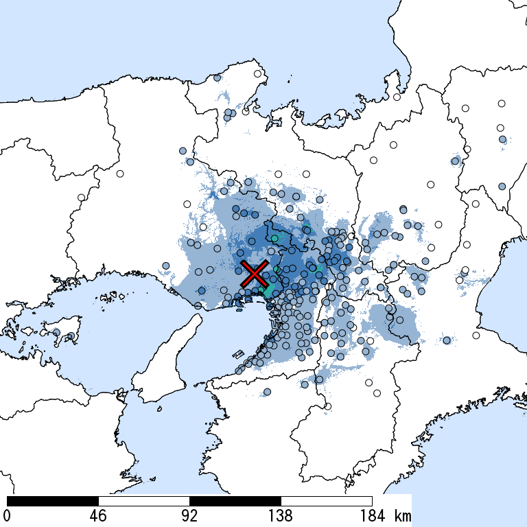
Seismic Intensity (Is) distribution is estimated from the observed data (circles) of NIED K-NET, KiK-net, JMA, and local governments that had been collected by 2022/09/24 03:44:13.
Estimated Is for Major Cities
| Max. Obs. Is | Histogram of Estimated Is |
Municipality
Show All Data | Nighttime Population | Distance [km] |
| 3 | Nishinomiya,Hyogo | 480,000 | 7 | |
| 3 | Kawanishi,Hyogo | 150,000 | 11 |
The histogram shows frequency distribution of estimated Is derived from interpolation of the observation with 250-m mesh. The daytime and nighttime correspond to 9:00-18:59 and 19:00-8:59, respectively. The distance is measured from the epicenter to the center of the municipality.
Is Exposed-Population Estimates of Each City

5- or greater
Not Available
|
|

6- or greater
Not Available
|

6+ or greater
Not Available
|

Population exposed to Is 5- or greater are not estimated.
Seismic Hazard Information of J-SHIS
J-SHIS is a Web service by NIED, to help prevent and prepare for earthquake disaster by providing a public portal for seismic hazard information across Japan.
Is Distribution of 2% Probability of Exceedance in 50 Years
Is Distribution of Return Period of 50,000-year


Major Historical Damaging Earthquakes in This Region
| Year | Region | M | Damage |
| 1925 | Northern Hyogo | 6.8 | Tajima Earthquake,428 dead, 1,295 houses collapsed, 2,180 houses collapsed from fire around the Maruyamagawa River. Two small faults (the length 1.6 km) were formed. |
| 1927 | Northern Kyoto | 7.3 | Kita Tango Earthquake,2,925 dead, 12,584 houses collapsed (5,105 houses, 7,478 non-residential houses). Goumura fault (a length of 18 km, the maximum horizontal displacement 2.7 m) and Yamada fault (a length of 7 km), which is perpendicular to Goumura fault, were formed by the earthquake. |
| 1936 | Nara | 6.4 | Kawachi Yamato Earthquake,9 dead. 6 houses collapsed, 53 partially destroyed. |
| 1948 | Kii Channel | 6.7 | 2 dead, 60 houses collapsed. |
| 1952 | Nara | 6.7 | Yoshino Earthquake,9 dead, 20 houses collapsed. |
| 1963 | Off Fukui | 6.9 | Echizenmisaki-oki Earthquake,2 houses collapsed, 4 partially destroyed. |
| 1995 | Awajishima Island | 7.3 | Hyogoken Nanbu Earthquake,Many timber houses, RC and steel framed buildings, expressways, and railways, including Shinkansen, collapsed. 6,434 dead, 3 missing, 43,792 injured. 104,906 houses collapsed, 144,274 partially destroyed, 7132 completely or partially destroyed by fire. |
| 2013 | Awajishima Island | 6.3 | The crustal earthquake with revers faults adjacent to the focal area of the 1995 Hyogoken Nanbu Earthquake. 35 injured, 8 houses collapsed and 101 partially destroyed. The maximum Is was 6- (Awaji-shi, Hyogo). |
Reference: National Astronomical Observatory of Japan, Chronological Scientific Tables, Maruzen, (2017) *partially extracted